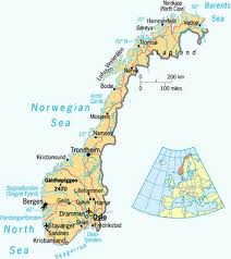
Geography of Norway

Total Area: 324,220 sq. Km
Land Area: 307,860 sq. Km
Water Area: 16,360 sq. Km
Highest Elevation: Mt. Everest, 8,850 m
Lowest Elevation: Turpan Pendi, 154 m
Total Distance of Coastline: 14,500 Km
Total Distance of All Land Boundaries: 22,117 Km
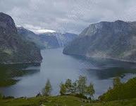
The climate of Norway is mild for its location due to the North Atlantic Current on the west coast. The terrain of Norway involves a few valleys and small plains, but up north it's artic weather with plenty of mountains. Norway borders three countries that are Russia, Finland, and Sweden. In comparison to the United States, it only has 324,220 Sq. Km. Making it smaller by 9,502,780 Sq. Km. Norway is a bit larger than New Mexico in comparison.
Land Area: 307,860 sq. Km
Water Area: 16,360 sq. Km
Highest Elevation: Mt. Everest, 8,850 m
Lowest Elevation: Turpan Pendi, 154 m
Total Distance of Coastline: 14,500 Km
Total Distance of All Land Boundaries: 22,117 Km
The climate of Norway is mild for its location due to the North Atlantic Current on the west coast. The terrain of Norway involves a few valleys and small plains, but up north it's artic weather with plenty of mountains. Norway borders three countries that are Russia, Finland, and Sweden. In comparison to the United States, it only has 324,220 Sq. Km. Making it smaller by 9,502,780 Sq. Km. Norway is a bit larger than New Mexico in comparison.
|
|