Geography of China
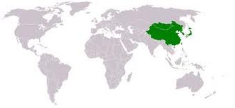
Total Area: 9,596,960 Sq. Km
Land Area: 9,326,410 Sq. Km
Water Area: 270,550 Sq. Km
Highest Elevation: Mount Everest, 8,850 m
Lowest Elevation: Turpan Pendi, 154 m
Total Distance of Coastline: 14,500 km
Total Distance of All Land Boundaries: 22,117 Km
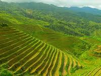
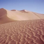
The climate of China varies, but essentially the Yangtze River divides China between North and South. The North has the colder weather to chill in during the summer while the South is perfect weather to relax in to get away from the cold weather during wintertime. The terrain of China consists of mountains, deserts in the west, and places of highlands. The fourteen countries that border China are Russia, India, Kazakhstan, Mongolia, Pakistan, Myanmar, Afghanistan, Vietnam, Laos, Kyrgyzstan, Nepal, Tajikistan, North Korea, and Bhutan. The total area of China falls short to the United States of America by 230,000 Sq. Km. It'd be the size of the United States if Minnesota didn't exist.
Land Area: 9,326,410 Sq. Km
Water Area: 270,550 Sq. Km
Highest Elevation: Mount Everest, 8,850 m
Lowest Elevation: Turpan Pendi, 154 m
Total Distance of Coastline: 14,500 km
Total Distance of All Land Boundaries: 22,117 Km
The climate of China varies, but essentially the Yangtze River divides China between North and South. The North has the colder weather to chill in during the summer while the South is perfect weather to relax in to get away from the cold weather during wintertime. The terrain of China consists of mountains, deserts in the west, and places of highlands. The fourteen countries that border China are Russia, India, Kazakhstan, Mongolia, Pakistan, Myanmar, Afghanistan, Vietnam, Laos, Kyrgyzstan, Nepal, Tajikistan, North Korea, and Bhutan. The total area of China falls short to the United States of America by 230,000 Sq. Km. It'd be the size of the United States if Minnesota didn't exist.
|
|

